HAITI
L'Union fait la force
Unity makes strength
Geography Overview:
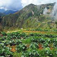
Haiti is a small island that emerged from Hispaniola and shares land with the Dominican Republic. Throughout Haiti, there is a tropical climate, lots of humidity, and it is characterized by high temperatures. They peak in rainfall in the months of April to November. The terrain on this island is predominantly lots of mountains with narrow valleys and low coastal lowlands. The highest point in Haiti is a peak called the Pic La Selle and the lowest point in Haiti is the Caribbean sea. Places like Pic La Selle can produce and contribute to the natural resources of Haiti like bauxite, copper, calcium carbonate, and hydroelectric power potential. Some major lakes include Etang Saumâtre and Peligre, and some major rivers include Artibonite and Les Trois. An abundance of Haiti’s natural hazards consist of water such as hurricanes, floods, earthquakes, and drought. Many of these disasters contribute to having another disaster throughout the towns. Hurricanes and tropical storms seem to start floods and earthquakes and drought seem to destroy homes and people. Disregarding all the hazards in Haiti, they have beautiful lands and appear to create wonderful plants and food for the community. The vegetation cover is mainly scrub, conifers, and leafy mangroves. Many farmers concentrate on subsistence crops, including cassava (manioc in Creole), plantains and bananas, corn (maize in Creole), yams and sweet potatoes, and rice but among the fruits that commonly grow in Haiti are mango, soursop (guanabana or “corossol” in the local lingo), guinep (quenepa or “kenèp” in Creole), avocados, plenty of citrus like orange, lemon, lime, mandarin oranges, and more! Overall, Haiti is a well-developed island with lots of community effort despite all the violence and natural endangerment.
Hand-Made Map:

Google Map:
Geography Photos:

Haiti geography on a map
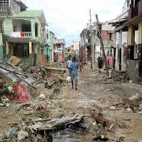
Aftermath of a tropical storm